
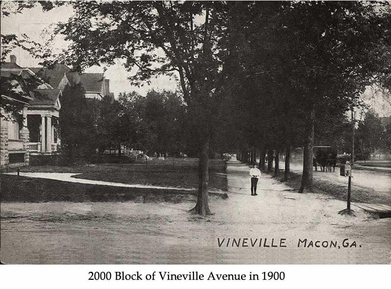
Vineville began in the early 1800s as an area full of large plantation estates and farms. Called Vineville Village, it was considered to be part of the rustic country and was well outside the Macon city limits. What is now called Vineville Avenue was built as a dirt road in the 1830s to connect Macon with the town of Forsyth. It ran along the Monroe Railroad and was one of the main ways to travel north.
During the Civil War, Vineville’s proximity to the railroad made it an ideal location to ship wounded Confederate soldiers. Hospitals were created on Pierce Avenue and on the land that’s now Hines Terrace.
By the 1890s, annexation of Vineville to the City of Macon became a controversial issue. Many Maconites felt the affluent tax base in Vineville should contribute to city services. There was also a push to increase the city’s population numbers ahead of the 1900 census. Vineville residents, however, wanted to retain their independent community. After a lengthy battle, the annexation bill passed in 1904.
During this same period, the farms and plantations began to be subdivided and the side streets leading off of Vineville Avenue laid out. The new houses reflected the changing times as the excesses of the Victorian period prompted a return to simpler designs and materials. Bungalows and cottages with wide front porches, porch posts, and natural materials like river stone and wood became popular.
Since then, Vineville has continued to grow and now has over nine hundred residences as well as churches, businesses and schools. Represented within our boundaries are examples of Plantation Plain, Victorian, Neoclassical, Bungalow and many other notable styles.
Read the in-depth history of the the Vineville neighborhood from our National Register of Historic Places nomination (small version, no pictures)
Below is a subset:
Vineville is a largely residential area located on a low plateau in the gently rolling fall-line terrain about a mile and a half northwest of downtown Macon. The area encompasses about 525 acres of land and includes more than 700 properties. It displays a heritage that began in the early-nineteenth century as a community of large agrarian estates and slowly evolved during the nineteenth and early-twentieth centuries into a compact, homogeneous suburb. Houses in this area date from the 1830s to the 1930s and range in size from large mansions to modest cottages. Early-nineteenth-century styles and types like the Plantation Plain are present, but late-nineteenth-century Victorian, turn-of-the-century Neoclassical, and early-twentieth-century Bungalow and Period houses predominate. These houses generally stand on long, narrow, rectangular lots, although a few larger tracts remain intact along Vineville Avenue. Front yards are landscaped informally with trees, shrubbery, and lawn. Streets form an irregular grid on either side of the elongated S-curve of Vineville Avenue, the central thorough[1]fare in the district. Many of the streets are lined with curbs, sidewalks, and shade trees. Several churches, a school, a small neighborhood commercial center and a small park accompany the houses in Vineville.
The natural terrain of Vineville is that of a gently rolling fall-line countryside situated upon a plateau above the Ocmulgee River and the City of Macon. The suburban streets are set upon this plateau, leading away from the elongated S-curve of Vineville Avenue like the ribs of a ship. These side streets are roughly gridded in plan, resulting from the construction of these streets along the property lines of the early estates that lay perpendicular to the avenue. The streets range from the long and wide expanse of Vineville Avenue, to short, narrow, and densely populated side streets and cross streets. Within this context, Stanislaus Circle is the exception, as its ovaloid street plan isolates its individual nature as an affluent mini-suburb; although its context is somewhat altered; the overall nature of this area remains an integral part of the Vineville district, enhancing the evidences of the evolutionary development of the Vineville suburb. Most streets are landscaped on either side like shaded parkways, with carefully aligned curbs, smooth lawns, flowering shrubs, and trees bordering or overhanging the streets. Building lots are laid out along every street in Vineville, ranging in size from several acres to more commonly—sized lots of one—third to one-half acre. Most lots form long and narrow rectangles, with frontages ranging from 50 to 150 feet, and depths ranging from 60 to 800 feet. The front yards are generally landscaped with lawns, shrubs, flowers, and trees in a natural or “romantic” manner, creating the consistent Impression of an inhabited public park. In many areas of the district, the street grade was cut into the landscape, resulting in the staging of the building lots and the creating of platforms for the construction of residences. These plat[1]forms are combined with the landscaping of the streetscape and building lots to effectually frame the structures with vegetation, creating an appearance not un[1]like the frame surrounding a fine painting. Backyards are entirely removed from public view and are landscaped for the many informal activities of the property owners. Houses in this area date from the early 1830s through the 1930s and range from the largest of mansions to the most modest bungalows and cottages. Predominate architectural styles range from the traditional Plantation Plain form of residence to the Eclectic revivalism of the early-twentieth century. Most evident are the late-nineteenth- and twentieth-century revival styles, such as the Spanish Villa, English Tudor, Italian Renaissance, Federal, Georgian, Jacobean, Neoclassical, and Bungalow; the Bungalow and Neoclassical styles reached a high level of development in the Vineville area. There is very little undeveloped open space in the district, and only one public park, at the intersection of Stanislaus, Pio Nono and Vineville Avenues.
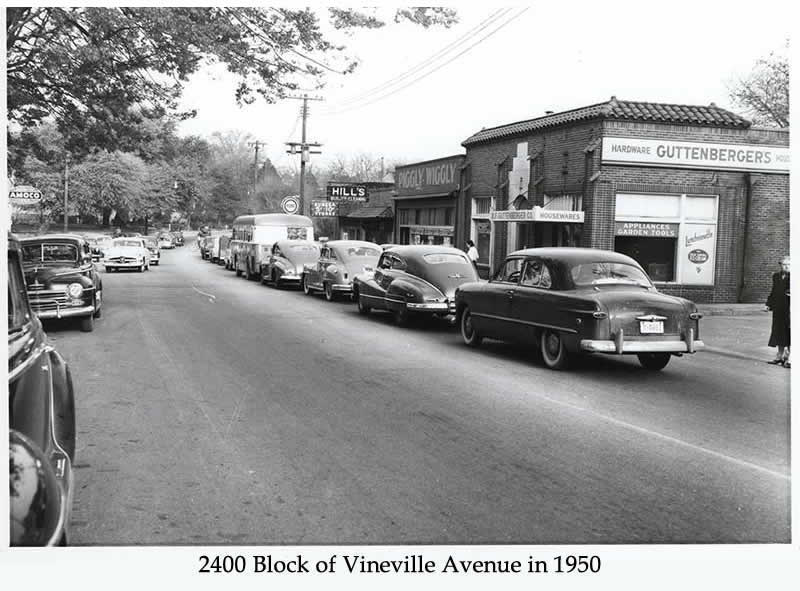
Each period of the evolutionary development of Vineville overlapped the previous period and has resulted in a pervasive homogeneity of the entire area. As a result, few sub-areas can be identified as having an individual sense or identity as a subdistrict within the whole. The Stanislaus Circle area is the only such subdistrict identified as a result of its somewhat isolated street plan. Most of the great architecture in the Vineville district was constructed along Vineville Avenue, while several other mansions are scattered along the side streets on larger building lots. Intrusions, though few in number, are scattered along Vineville Avenue, while a few isolated low-rise apartment buildings have been constructed along side streets (most notably on Calloway Street and Rogers Avenue). At the Intersection of Buckingham Street, Calloway Street and Vineville Avenue is located a small commercial center for the neighborhood, consisting of a half dozen 1950s row shops (now mostly vacant), a convenience store, and a late-1950s supermarket, now converted for use by small specialty shops.
Overall, Vineville is characterized by continuity in its natural terrain, landscape architecture, street plan, and site planning, as well as in the scale and quality of its architecture and streetscape. Vineville is an exceptionally well-preserved nineteenth- and twentieth-century suburb, with few non-detracting structures and even fewer intrusions.